
|
| Hunsbury Hillfort |
| Home | Events & Notices | Recent Discoveries | Publications | Links | How To Join | Contact Us |
A new survey to assess the condition of both the interior and the surviving rampart of the hillfort at Hunsbury has been partially completed in the early months of 2004. This is summarised here while a full interim report has been circulated and is available from the NAS.. The work to date has been financed under a project called CREATE IT, a scheme organised by the Parkinson's Disease Society, and funded by the Millennium Commission. English Heritage has provided additional funding which will allow the project to continue over a longer period.
 |
| A decorated scabbard from Hunsbury |
Iron Age hillforts are common in many parts of Britain and there are at least six in Northamptonshire. The internal rampart at Hunsbury however appears to have been burnt down and vitrified, and such forts are rare in England. During the period between 1880 and 1886, ironstone quarrying began within the hill fort at Hunsbury. An attempt had been made to have the hillfort protected under the new Ancient Monuments Act of 1882, but this failed because of the likely cost of compensating the landowner and therefore quarrying proceeded. Removal of the topsoil revealed as many as 300 pits measuring between 5 and 10 feet (1.5 - 3 metres) in diameter and up 7 feet (1.8 metres) in depth. As Thomas George, the curator of Northampton Museum, observed in 1887:
| "They were full of black mould and in them were found the numerous artefacts that now comprise one of the finest collections, I believe, of Prehistoric antiquities in England" |
Today the hillfort is part of a country park, surrounded by a housing development Although the site is owned by Northampton Borough Council and is a Scheduled Ancient Monument, it is currently not in a good condition. The banks, some of which were undercut by the 19th Century quarrying, have become badly eroded in parts. The bank and ditch are covered by shrubs and trees, the roots of which continue to damage what is left of the archaeological deposits, as do numerous rabbits.
SITE HISTORY
The following is a brief history of the development of the site over the past 2500 years.
THE 1998 SURVEY
The survey carried out in 1998 by RPS Clouston covered the whole of the defences and not just the internal rampart. Each of the elements were discussed in detail. The variety of remedial work presented was all costed and the following is a list of their main options:
 A section of the rampart damaged by trees and rabbits |
|
THE 2004 SURVEY
The 2004 survey began by re-examining the state of the hillfort and reconsidering the possibilities for remedial work with an additional option: backfilling the quarried area with sterile waste. Much of the surviving rampart at Hunsbury is perched above a quarry face, and the original aim of the study was to form a committee to look into the feasibility of filling the quarried area with sterile waste. It was felt that this would make it easier to preserve the remaining rampart and perhaps improve the environment around the hillfort.
After
due consideration it was decided that although backfilling parts of the quarry
was a practical proposition, there were other aspects that needed to be considered.
Not least of these was the cost, particularly after it was considered that parts
of the rampart are now so badly eroded that it is probably not worth trying to
preserve it. Other factors taken into consideration were the fact that the ironstone
quarrying is now part of the history of the site and that the evidence for this
should also be preserved. Another factor was the amount of work now needed to
control the spread of vegetation
As the project developed it became clear that
many of the problems were interlinked. In consequence it was decided to evaluate
the surviving archaeology of the hillfort in order to suggest the most effective
ways of preserving them. The following work has been undertaken to date. A first
step in this scheme was to locate the precise edge of the quarried area within
the interior of the fort, and geophysics and trial trenching achieved this
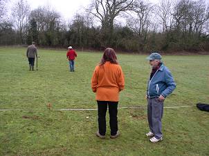 |
| Dennis Jackson oversees the geophysical
survey of the hillfort interior |
Northamptonshire Archaeology, to locate the quarry edge carried out a geophysical survey in March 2004. The results of the survey are held in archive (the survey covered three 20 metre squares with readings every 1m) The survey revealed a possible edge to the quarry as well as anomalies which could represent archaeological features however both of these elements required to be confirmed by trial trenching.
 |
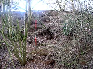
| Trial trenching reveals the quarry
edge (marked by ranging poles) |
Between the 19th and 21st March 2004, three trial trenches were excavated within the hillfort interior. Three trial trenches were excavated within the hillfort by volunteers from the Northamptonshire Archaeological Society, directed by Dr Martin Tingle, primarily to confirm the position of the quarry edge. Three parallel trenches, were excavated from an area assumed to be unquarried , with the intention of locating the quarry edge and determining the nature of any surviving archaeological remains. They were each 80cms wide and varied in length from 8 metres to 15 metres. Trench 1 revealed a group of 3 large pits while in Trenches 2 & 3 other less substantial features were encountered. Comparing the results of the trial trenching with the location of the quarry edge that was assumed from nineteenth century records, it appears that the surviving area is larger than had been previously imagined. The trenching has revealed that there is between 25 to 35cm of plough soil above the natural bedrock of ironstone grits or silty clay, and that no Iron Age levels survive in the area of the trenches. There is no evidence that overburden was dumped on the unquarried area during the quarrying .
 |
| One of the pits in Trench 1 -
it was from similar pits that a remarkable assemblage of Iron Age metalwork was
recovered during 19th Century quarrying |
Several large pits were exposed in Trench 1, but overall the density of features revealed in the trenches is low. Parts of the unquarried area seem likely to have suffered from plough erosion as the present ground surface slopes down towards the edge of the old quarry. If this is so shallow archaeological features may have lost in this area.
A second geophysical survey was carried out surveying the whole of the surviving area at the east end of the hillfort. EAS LTD undertook the work with readings taken every 25cms. The results of the second geophysical survey, in conjunction with the trial trenching, show that the edge of the quarry is further to the west (on average 10 metres) along most of its line than originally envisaged by the R.C.H.M. The evidence from the trial trenching however suggests the bulge eastwards (shown by the geophysical survey) at the south end of the line is probably misleading. The survey is comprehensive and has revealed a number of pits together with one and possibly two circular structures. Over large areas however the magnetic anomalies are too dense to define individual features.
THE RAMPART
 |
| Geophysical survey
results revealing the extent and intensity of the rampart burning |
A geophysical and contour
survey has been undertaken around the whole of the rampart. This has shown that
layers of burning and probable destruction by fire, occur around most if not all
of the circuit
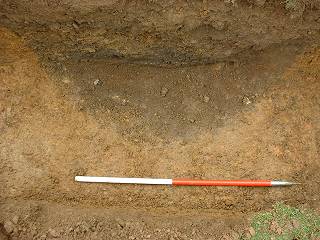
[Insert Hunsbury 6, caption ]
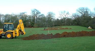
Three trial cuts along the inner face
As part of the survey three narrow trenches (Cuts 1-3) were cut back mechanically to the old quarry face, one each on to the north?cast, south and west sides. The purpose was to assess the ramparts present surviving height and its nature or phase. The maximum surviving height of the rampart in the trenches dug in 1952 and 1988 was 1.8m.
There is no evidence of any of the layers from the Phase 2 rampart surviving in the area of the trenches excavated on the north?east and south sides of the fort. The homogeneous nature of the make-up suggests the surviving rampart is probably part of the core of the Phase 1 structure. It seems likely that this is true of the whole of the north and south sections.
There are clearly two phases of rampart shown in the east section excavated near the entrance in 1952, but there is no evidence that this reconstruction phase continued right round the hillfort. Possible Phase 2 layers survive in the north-west and west sections, but these are being badly eroded.
The condition and preservation of the Rampart in early 2004
An environmental survey has been carried out to assess the damage being caused to the rampart by erosion, rabbits and the vegetation, The survey illustrates how the various problems are interlinked and considers the best approach with limited finance may be to gradually change the conditions
The condition of the rampart, and the vegetation cover, varies around the circuit and it is suggested that it may be an advantage to treat individual sections differently. If money were available, however, it would be better to employ tree surgeons and contractors to prune and manage the trees and bushes over the whole of the defences as a first stage.
Comment: Most of the options presented by the survey in 1998 could prove very expensive and all areas are treated equally. It is suggested by the new survey that the rampart on the east side is under little threat and on the north-east and north-west it is probably too eroded to be worth preserving. In the near future, it may be preferable to carry out the measures recommended for the preservation of the rampart on the south and west sides of the fort.
Future excavation of the Rampart
There are certain areas of the rampart which are difficult to preserve but where excavation may provide valuable new evidence. In the short term the following four locations are worth considering for excavation:
In the longer term it is probably important to learn more about the vitrification of the fort. In this context Mr Peter Crewe of the Hillfort Study Group has suggested the excavation of a 20m wide section through the rampart, and this could be associated with a planned reconstruction of a section of the rampart. This trench could be positioned in the north?west or west sectors where Phase 2 layers survive, but are being lost to erosion.
Further
work on the Interior and Exterior of the Defences
Several large pits were revealed by the earlier trenching in the interior, and it is possible that the excavation of a group of pits, at some stage, could provide invaluable environmental evidence, and may help to put some of the finds from the hillfort into context.
What was thought to be a substantial outer ditch was located at several points during earlier quarrying and it is likely that its presence could be established by a geophysical survey in the unquarried area. If contemporary an outer enclosure could have been used for corralling stock, although it is could be unrelated to Iron Age activity. Confirming the presence of this ditch could be a priority in any future programme. A limited geophysical survey in 1998 located a ditch to the east of the defences and it has been suggested that a larger area remains unquarried to the south of the fort.
A Management Plan
Ideally the archaeological work needs to be carried out under a management plan in which all aspects are discussed, and a plan of action agreed by interested parties. The question of public access and vandalism needs to be solved with cars being driven into the fort and dumped at frequent intervals
 Display
Boards
Display
Boards
A new display and information board has been ordered and will be erected on the site. At present there is nothing to inform visitors about the history of this important site.
Acknowledgements: thanks are due to Graham
Cadman, Andy Chapman and Robert Moore for their help and advice in preparing this
study.